
The Mystery of Anosibe Ambohiby
Uncovering the Story of Anosibe Ambohiby: A Remote Village on Madagascar’s Ancient Volcanic Crater, Isolated Yet Thriving Amidst Vast Landscapes, Fertile Soil, and a Rich Geological Pas

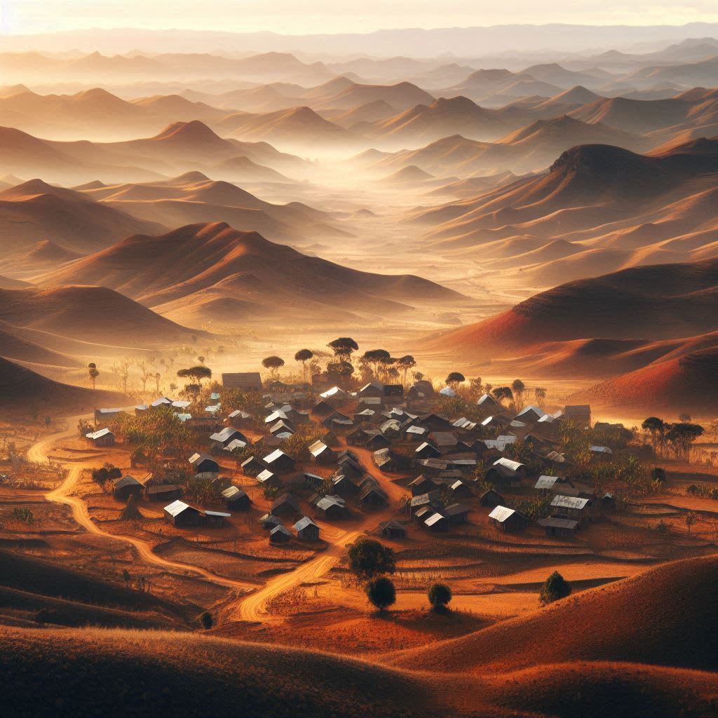
Madagascar is an island located off the coast of Africa. It's known for being one of the most biologically diverse places in the world. Most of its plants and animals are unique to the island. When viewed from space, a striking dark circle appears over thirteen kilometers wide. This circle is a mountain. Zooming in, you can see a village inside its crater. It lies 8 kilometers from the nearest labeled town on Google Maps, making it quite remote. The village seems to have been there for generations, but looking back in time shows that it has shrunk over the years. Before 2008, no one lived there at all.
This raised an interesting question: Why did people move to such an isolated location? I wanted to find out but had no connections in Madagascar and limited knowledge about the island. The challenge was to reach out to the villagers using the internet. The closest location tags pointed to a butcher shop, playground, and a historical landmark, but these references turned out to link to the Japanese series Attack on Titan, written in Russian!
Other local tags, like churches and schools, lacked a strong online presence. We then searched for geotagged content on Twitter and eventually found a nonprofit worker who posted in a nearby village in 2014, but he never responded to our inquiry. We turned to Instagram and discovered an aid organization that didn’t have any information about the village either.
Finally, we found a video on YouTube geotagged next to the village, but it was more Attack on Titan content. Frustrated, we decided to contact experts who had experience in Madagascar, including those in agriculture and biogeography. A country of nearly 29 million residents, Madagascar's rural population exceeds 60 percent. Our village stood apart due to its extreme remoteness, with the nearest major city—Tsiroanomandidy—over 18 kilometers away and home to more than 44,000 people.
Feeling stuck, we explored new options. Perhaps we could hire someone local to visit the mountain and the village. That’s when we met Lalie, who runs a production company in the capital, Antananarivo. She was eager to take on the journey and set about assembling a crew and local contacts. They prepared to travel during Madagascar’s hot rainy season. In January, they set off.
Toussinah was their guide, Haja was the historian, Vahambola was the fixer, and José was the driver. Lalie kept us updated as they approached the mountain. After a long trek, they reached the top, but a storm forced them to turn back before they could reach the village. They got close, but meeting the villagers would have to wait until the rainy season ended in May.
After months of research, we learned about the area. The landscape looked lush but challenging to navigate. Before Lalie's January visit, she had doubts about whether anyone lived there. A simple search led us to an article about Madagascar's earthquakes. Researchers created a seismic map of the island that revealed a circular area in the mountain.
This circle indicated that the mountain dates back to the Cretaceous Period, over 66 million years ago, and it’s volcanic. To confirm this, I consulted a volcano expert, Tsilavo Raharimahefa. His findings indicated that the mountain is about 90 million years old—much older than well-known geological features like Mount Everest and the Grand Canyon.
The age of the volcano raises intriguing questions about how it relates to the breakup of Madagascar and India. We sought experts in this area, like geologist Joe Meert, who explained the formation of volcanic hotspots and how Madagascar once floated above one. As tectonic movements occurred, the volcanoes formed and later collapsed, leaving behind remnants of this ancient system.
After several attempts, we finally identified the mountain as the Ambohiby Massif, named by a mineralogy site. Historical maps labeled the area as a lush forest. Reports from the 1930s noted an open valley known for its fresh water, likely attracting villagers for both water and space.
After several detours, we found a 2012 academic paper about the Ambohiby Massif, authored by Ndivhuwo Cecilia Mukosi. She took rock samples from the area years ago, suggesting she interacted with the local people, though she studied the site before the village emerged.
With the rainy season ending, we had a chance for Lalie and her team to visit again. They embarked on the journey to Tsiroanomandidy, picking up a new guide, Johary. He had climbed the Ambohiby before but hadn’t visited the village at its center. Close neighbors offered insights about the community, but the ascent to the village would take a full day. Early the next morning, they set out to explore.
Upon arrival, they encountered the village bustling with life.
About the Creator
THiNK
Think - Your go-to destination for exploring captivating mysteries, insightful psychology, intriguing facts, and the latest news. Our mission is to spark curiosity and inspire learning. Join us as we uncover the unknown!


Comments (3)
I am doing a Independent work project on Anosibe Ambohiby and this site gave me everything I needed
great work
interesting!