


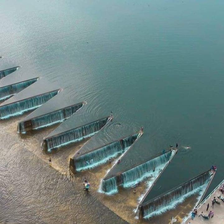
Pimburaththewa Lake, also known as Pimburattewa Tank, is one of Sri Lanka's most popular tourist spots. Polonnaruwa District's Aralaganwila has Pimburaththewa Lake. It is well-liked by the locals as a swimming location. Beautiful vistas of the Polonnaruwa district's lush green trees surround the lovely lake. Pimburaththewa Lake is the perfect location to take a bath if you're visiting Polonnaruwa. The Pimburaththewa Tank is primarily recognized by its lake's water spill design. The water spill is made up of a lot of triangles. There are more than five water spills with triangle designs. It is a must-see location when in Polonnaruwa. Although it is not a waterfall like the one in Polonnaruwa, it appears to be a collection of waterfalls.
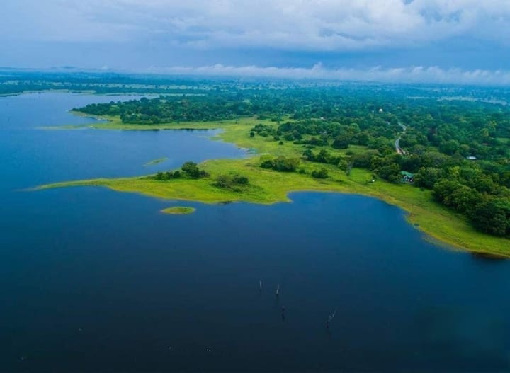
If you plan to visit Pimburaththewa Tank, you should exercise caution. Elephants frequently wander the region in search of water. Because elephants frequently emerge in the evening, exercise caution when bathing at this lake. The beauty of this is also accessible during the wet season. However, it's important to use caution when bathing in the rainy season. One of the best places to see the sunset is at Pimburaththewa Lake. Therefore, if you're in Polonnaruwa, try to have fun.
If you plan to visit Pimburaththewa Tank, you should exercise caution. Elephants frequently wander the region in search of water. Because elephants frequently emerge in the evening, exercise caution when bathing at this lake. The beauty of this is also accessible during the wet season. However, it's important to use caution when bathing in the rainy season. Pimburaththewa Lake is a fantastic location to view the setting sun. Therefore, if you're at Polonnaruwa, try to have fun.
History
The Pimburaththewa lake was built as part of a Sri Lankan project by the Mahaweli Authority. the reservoir built to supply water for agriculture in the Aralaganwila region. Additionally, Pimburutthewa by Mahaweli Authority Sri Lanka has a vacation home.
How to Get
- Travel along the Maradankadawala-Habarana-Thirukkondaiadimadu Highway from Polonnaruwa
- Then drive along the Manampitiya-Aralaganwila-Maduru Oya Road and reach Aralaganwila
- Reach the Pimburaththewa Tank
Places Near
- Wasgamuwa National Park
Wasgamuwa National Park is situated in Sri Lanka's Polonnaruwa and Matale Districts, some 50 kilometers northeast of Kandy. The Sudukanda Mountain Range, which extends from north to south between the Amban Ganga and Mahaweli Ganga rivers, dominates the park and isolates it on all except its southern edge. The park is next to the Riverine Nature reserve on the right bank of the Mahaweli Ganga and is a little over 39,000 hectares. Wasgamuwa National Park, a significant hub of prehistoric Sri Lankan civilization, had been neglected for a while but is currently seeing a resurgence in popularity.
- Maduru Oya National Park
One of Sri Lanka's national parks is the Maduru Oya National Park. On November 9th, 1983, a national park designation was made for it. It was built as part of the Mahaweli development project and serves as the reservoir's catchment area. It is 58,849 hectares in size, situated 314 kilometers from Colombo in the dry zone, and serves as a wildlife sanctuary.
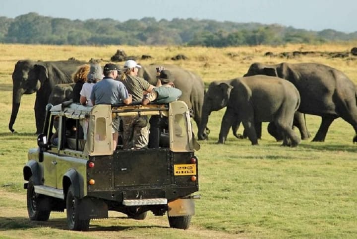
The habitat for elephants in the Maduru Oya National Park is well-known. Wild species such as leopards, sloth bears, sambhur, spotted and barking deer, wild boar, and wild buffalo are among the non-elephant wildlife. The park is also home to the Toque Macaque, Purple-faced Langur, Slender Loris, Black-Naped Hare, Indian Pangolin, and a variety of squirrel species. Over 100 kinds of birds, including the Lesser Adjutant, Woolly Necked Stork, Openbill, Painted Stork, Racket Tailed Drongo, Yellow-fronted Barbet, Sri Lanka Jungle Fowl, and Spur Fowl, are also found there in addition to wild animals. However, within the limits of Maduru Oya National Park, there is a community of Veddas who are native to Sri Lanka.

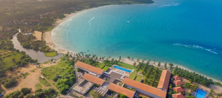
- Pasikudha Beach
About 35 kilometers from Batticaloa Town, Pasikuda, which means "green-algae-bay," is located on the eastern shore of Sri Lanka between Kalkuda and the Indian Ocean. Local and foreign visitors are drawn to this expansive sandy area by the bay's turquoise blue seas to surf, swim, or simply enjoy the water's warmth. There are other additional activities available, including kite- and boogie-boarding, surfing, and canoeing.
Read : https://zeloan.blogspot.com/2022/10/pasikuda-beach-in-sri-lanka.html
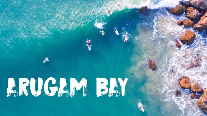
- Arugambe Beach
Arugam Bay, sometimes referred to as "Arugam Kudah" locally, is a historic hamlet of the former Batticaloa Territory and is located on the Indian Ocean in the dry zone of Sri Lanka's southeast coast (Mattakallappu Desam). The bay is around 4 kilometers (2.5 mi) south of the market town of Pottuvil and 117 kilometers (73 km) south of Batticaloa. It is also 320 kilometers (200 mi) due east of Colombo. The area's primary community, Ullae, is primarily Muslim, but to the south of the village, there are sizable Sri Lankan Tamil and Sinhala populations as well as a handful of foreign expats, mainly from Europe and Australia.Although historically fishing has been the main industry in the region, tourism has developed significantly in recent years. Bay of Cynodon dactylon is the exact Tamil translation of Arugam Kudah. Several good surf breaks make Arugam Bay a popular destination for surfers, but the area's beaches, lagoons, historic temples, and adjacent Kumana National Park all draw visitors.
Read : https://zeloan.blogspot.com/2022/07/arugam-bay-in-sri-lanka.html
- Pigeon Island
Two tiny islands north of Trincomalee off the east coast make up Pigeon Island National Park. The Blue Rock Pigeon, a local, threatened species that inhabits the rocks of these islands, gave the island its name. In order to safeguard these birds, the islands were designated as a sanctuary in 1963. The region was given national park status in 2003, and the coral reefs surrounding it were added to the park's limits. The Eastern Province seaside town of Nilaveli is located 1 km from the shore of the national park, which has a total land size of 471.429 hectares.
Read : https://zeloan.blogspot.com/2022/08/pigeon-island-in-sri-lanka.html

- Danigala Mountain
Kandegama Rock and Alien Mountain are other names for Danigala Circular Rock. In Sri Lanka's Polonnaruwa district, it is located close to Aralaganwila. The Danigala mountain is 280 meters high (919 ft). the most beautiful location is apart from people. The fog is adding to the valley's splendor as it sets, giving a spectacular 360-degree panorama. It looks like an airport where extraterrestrial spaceships might land when viewed from above. The Pamburugala Kanda, Amunugala Kanda, Hikkagala Kanda, and Henanigala mountain ranges may all be seen from the summit of the Danigala mountain range. Danigala Rock is one of the most difficult mountains to climb.
An archeological reserve called Danigala Rock is located on the Maduru Oya boundary. The Maduru Oya dam is supported by the rocks known as the Danigala and Kamburagala. While Kamburagala rock is located in the Ampara district, Danigala/Kandegama rock is in the Polonnaruwa district. The border between the districts of Polonnaruwa and Ampara is the Maduru Oya.
Read : https://zeloan.blogspot.com/2022/09/Danigala%20Mountain.html

Google Map:
About the Creator
Zeloan
I'm a Traveller, Blogger, and Content Creator. Visit Sri Lanka, and you can see the most beautiful places in the world and the remarkable hospitality here
Modi's important diplomatic mission in Israel, major progress expected on defense and strategic cooperation
Israel: Indian Prime Minister Narendra Modi is currently on an official visit to Israel where he has held high-level meetings with the Israeli leadership, however, no formal announcement of any major final agreement has been made so far. This visit has assumed extraordinary importance in the context of the changing geopolitical, political and security situation in the region, especially at a time when rapid changes are taking place in the defense and economic alignments in the Middle East. Narendra Modi held detailed and comprehensive discussions with the Israeli Prime Minister and other senior officials on important topics such as bilateral relations, defense and security cooperation, modern technology, counter-terrorism, development in the agricultural sector, water resource management, investment and promotion of mutual trade. According to sources, the talks in the defense sector remained at the forefront as India has become a major buyer of advanced defense equipment from Israel in recent years and talks are underway to further expand cooperation in drone technology, missile systems, advanced border surveillance equipment and other security technologies.
By Malik Sarfraz Hussain Awan3 days ago in Journal
Pearl
1980 something. we all hung out at Pearl and you and i were nothing special, or so i thought. i mean we all danced, drenched in our own sweat, our own saline solution of fear, too many beers, shots, laughter, tears, fucks in the bathroom and i don't know when we began to be afraid. do you?
By ROCK aka Andrea Polla (Simmons)3 days ago in Fiction


Comments
There are no comments for this story
Be the first to respond and start the conversation.