
India vs Pakistan war 2025
Satellite Images Reveal Damage to Terror Camps in Pakistan Following Operation Sindoor


Satellite Images Reveal Damage to Terror Camps in Pakistan Following Operation Sindoor
**Before and After: Satellite Images Show Damage to Terror Camps in Pakistan After Operation Sindoor**
**Introduction: What is Operation Sindoor**
On May 7, 2025, India launched a military operation named Operation Sindoor. In response to an April 22 terrorist attack in Indian-administered Kashmir, this operation was carried out. That attack killed 26 Hindu tourists. The Indian government blamed terrorist groups based in Pakistan for the attack.
India carried out air strikes against a number of Pakistani terror camps. These camps were believed to belong to groups like Jaish-e-Mohammed and Lashkar-e-Taiba. Both groups have been involved in previous terror attacks against India.
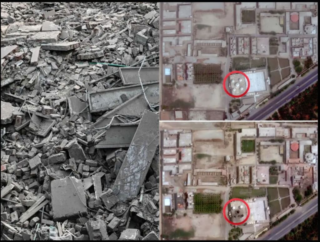
After the operation, satellite images were released showing how the targeted camps looked before and after the air strikes. These images clearly show the damage caused by the Indian Air Force during the operation.
**What Satellite Images Show**
Before the air strikes, the satellite images showed several large buildings and camps. These were far from bustling cities in Pakistan's remotest regions. The buildings were said to be used as training centers and shelters for terrorists. The images showed structures in good condition, with no signs of damage. Some of the camps were even surrounded by walls and watchtowers.
New satellite images released after the strikes revealed a significantly different picture. Many buildings had been destroyed. There were large craters in the ground where the bombs had exploded. Some areas were blackened by fire. Some structures were completely reduced to rubble. In many places, the damage was total, with nothing left standing. These images confirmed that the air strikes were very accurate and hit their targets directly.
**The primary targets are Muridke and Bahawalpur** Bahawalpur and Muridke were the two main targets in Operation Sindoor. Bahawalpur is believed to be the home base of the Jaish-e-Mohammed terror group. It is in Pakistan's Punjab province. Before the strikes, satellite images showed a large compound there with several buildings. After the operation, the images showed the compound was almost completely destroyed. Most of the buildings were gone, and large craters could be seen in the ground.
Muridke is believed to be the headquarters of Lashkar-e-Taiba. This group was behind the 2008 Mumbai terror attacks. Muridke is in close proximity to Lahore. Satellite images showed a large campus with many buildings before the air strikes. After the strikes, many of these buildings had been damaged or destroyed. The satellite pictures showed clear signs of bomb damage, with roofs blown off and walls collapsed.
These two examples show how the operation was carefully planned and carried out. The air strikes targeted specific terrorist locations without harming nearby civilian areas.
**How the Operation Was Carried Out**
According to Indian defense officials, the air strikes were done with great care and precision. Fighter jets crossed the Line of Control during the night and flew deep into Pakistani airspace. They used guided bombs and missiles to attack the camps.
The Indian Air Force chose to strike at night to avoid civilian casualties. They used advanced surveillance technology to make sure the buildings were empty of civilians at the time of the strike. The goal was to damage only the terror infrastructure and avoid harming innocent people.
Defense experts say that the bombs used in the operation were smart bombs. These bombs can be guided to hit a specific point. That is why the damage was so focused. The fact that most of the surrounding areas remained unharmed demonstrates the attack's accuracy. **India's Statement on the Operation**
India has said that the purpose of Operation Sindoor was to stop terrorism at its roots. Government officials said that Pakistan has allowed terrorist groups to use its land to plan attacks against India. India said it has the right to protect its people and stop future attacks by destroying the training camps.
Indian leaders said the operation was a success. They praised the armed forces for their bravery and skill. According to Indian officials, no Indian soldier or pilot was harmed during the operation. The government also released some of the satellite images to the public to show the success of the strikes.
**Pakistan's Reaction**
Pakistan strongly denied the presence of terror camps on its land. Pakistani officials said that the Indian strikes violated their country’s airspace. They called the attack an act of aggression and warned that they would respond if needed.
The Pakistan government also said that no terrorist camps were hit and that India was spreading false information. However, independent satellite images appeared to support the destruction of some structures in India's target areas. Pakistan’s military said it had scrambled fighter jets to intercept the Indian planes, but they had already returned across the border. Pakistan also warned that it would take steps to defend its sovereignty.
**International Response**
Countries around the world reacted differently to the operation. Some countries supported India's right to self-defense and said it had the right to strike back against terrorism. These countries asked both sides to stay calm and avoid further violence.
India and Pakistan were urged by other nations to engage in dialogue to resolve the conflict. The United Nations pleaded for tranquility and requested that neither nation engage in further military conflict. The situation remains tense, as both India and Pakistan are nuclear-armed countries.
**Role of Satellite Images**
Satellite images played a very important role in this operation. They helped the Indian Air Force plan the strikes with accuracy. After the operation, they also helped the government show the results to the world.
These images were taken by commercial satellites and defense satellites. They clearly show how the buildings looked before and after the strikes. The changes in the images provide evidence that the operation had an impact.
Some defense analysts said the use of satellite imagery is important in modern warfare. It helps governments and people know the truth about military actions. It also helps avoid misinformation and confusion.
**Impact on the Region**
Operation Sindoor has increased tensions between India and Pakistan. The possibility of additional attacks or strikes in the future is feared. The armed forces of both nations are on high alert. The people living near the border are also scared of more fighting.
The operation has also started a new debate in the international community about cross-border terrorism. Many people are asking whether countries have the right to strike targets across borders if they are fighting terrorism.
India has said it will continue to protect its citizens and will act again if necessary. Pakistan has said it is ready to defend itself. The situation remains uncertain, and the world is watching closely.
**Conclusion**
India launched a significant military operation known as Operation Sindoor in response to a deadly terrorist attack. It targeted terror camps inside Pakistan that were believed to belong to groups like Jaish-e-Mohammed and Lashkar-e-Taiba. Satellite images before and after the strikes clearly show the damage done to these camps.
Using cutting-edge technology, the operation was carefully planned and carried out. It has increased tension between India and Pakistan, and the international community is calling for peace. As things stand, the future of relations between the two countries remains unclear.
Satellite images will continue to play a key role in how the world sees and understands such events. They provide proof of actions taken and help build trust or expose false claims.
India has sent a strong message with Operation Sindoor. The world will be watching how both countries respond in the coming weeks.
---
Would you like this article converted into a PDF or printable format?
About the Creator
New Video Emerges Showing Alex Pretti Confronting Federal Agents 11 Days Before Fatal Shooting
The Video in Question The newly surfaced video shows Alex Pretti engaging with federal agents 11 days before his fatal shooting, raising questions about the sequence of events leading to the tragedy. The footage, shared by local media outlets and circulated widely on social media, depicts Pretti in a heated confrontation, though details remain partially unclear due to the nature of the recording.
By Aarif Lashariabout 9 hours ago in Journal


Comments (1)
nice