
‘100 Foot’ Waves Reportedly Heading for the U.S. as Hurricane Erin Approaches
Hurricane Erin Approaches As "An Avalanche"

The Atlantic hurricane season has once again reminded us of its raw, untamed power. As Hurricane Erin barrels toward the United States, meteorologists warn that giant waves—some reaching up to 100 feet—could impact parts of the East Coast. While the storm itself has weakened from Category 5 to Category 3, experts caution that its oceanic force remains capable of creating hazardous surf, rip currents, and storm surge conditions long before landfall.
In this in-depth report, we’ll explore:
How hurricanes like Erin generate massive waves
Expert predictions about the 100-foot wave possibility
Which U.S. states are most at risk
The science of rip currents and coastal hazards
Historical cases of mega-waves caused by hurricanes
Essential safety tips for residents and beachgoers
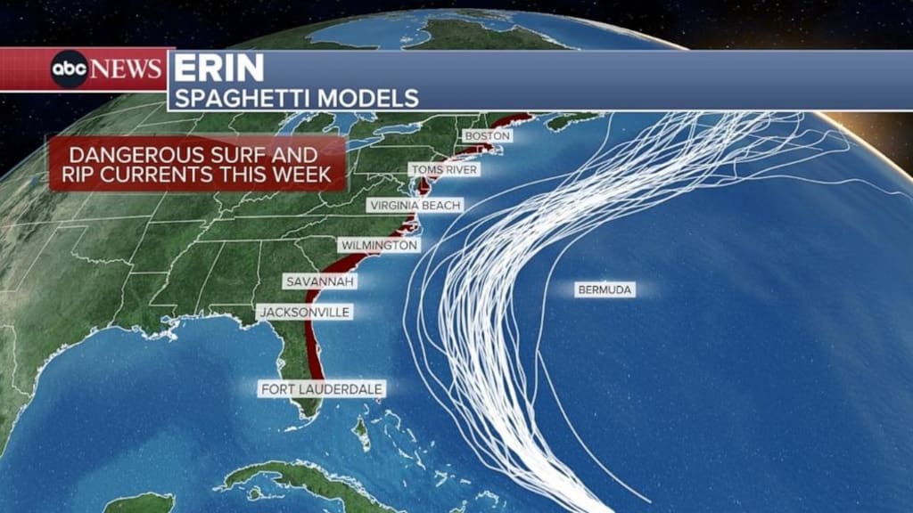
The Storm So Far: Hurricane Erin’s Path and Impact
Hurricane Erin formed in the warm waters of the Atlantic earlier this month and quickly intensified to a Category 5 hurricane—the most dangerous classification on the Saffir-Simpson scale. Packing winds of over 160 mph, Erin wreaked havoc across the Virgin Islands, Puerto Rico, and the Turks and Caicos Islands, leaving widespread flooding and infrastructure damage.
As it tracks northwest, Erin has weakened to a Category 3 hurricane. But meteorologists warn: don’t let the downgrade fool you. Even at this level, the storm brings:
Sustained winds above 115 mph
Rainfall measured in feet rather than inches
Widespread potential for storm surge
More importantly for U.S. residents: Erin is generating ocean swells capable of traveling hundreds of miles, reaching the East Coast well before the eye of the storm.
Could Waves Really Reach 100 Feet?
The phrase “100-foot waves” sounds like something from a disaster movie. But according to leading scientists, it is not impossible.
Expert Insight: Jean-Raymond Bidlot (ECMWF)
Jean-Raymond Bidlot, a senior scientist in ocean modeling at the European Centre for Medium-Range Weather Forecasts (ECMWF), told Newsweek:
“The latest forecast does indeed indicate that the largest significant wave height could reach values in excess of 50 feet with an associated most likely largest wave of more than 100 feet.”
In other words, while average waves near Erin may measure 50 feet, isolated rogue waves could double that height.
Counterpoint: Alex DaSilva (AccuWeather)
Not all scientists agree that U.S. waters will see waves that extreme. AccuWeather’s lead hurricane expert Alex DaSilva notes:
“While 100 feet can’t be ruled out, I think they would only be possible if the storm becomes a Category 4 or 5 again. Waves near the center of 50–75 feet are much more realistic assuming a Category 3 storm.”
Why Hurricanes Generate Such Giant Waves
To understand why Hurricane Erin is capable of sending monster waves toward the U.S., we need to look at the science of ocean-atmosphere interaction.
Wind Strength: Strong winds transfer energy to the ocean surface. Hurricanes produce sustained winds at 100–160 mph, generating enormous swells.
Fetch: The distance wind travels over open water. Erin has a wide fetch across the Atlantic, meaning waves have time and space to build.
Storm Duration: The longer a storm sustains high winds, the more energy is imparted into the ocean. Erin’s longevity adds to wave height.
Wave Propagation: Unlike winds, waves radiate outward from the storm center. They can travel hundreds of miles to impact coastlines far removed from the hurricane’s eye.
This is why U.S. beaches could experience hazardous surf even if Erin never makes direct landfall.
Which States Are Most at Risk?
While exact landfall predictions change daily, forecasters warn that Erin’s swells could affect much of the Eastern Seaboard. States most likely to experience dangerous waves and rip currents include:
Florida – Especially the Atlantic coast near Miami and Daytona Beach.
Georgia & South Carolina – Charleston is historically vulnerable to storm surge.
North Carolina – The Outer Banks are already under advisories.
Virginia & Maryland – Swells could amplify tidal flooding in the Chesapeake Bay.
New Jersey & New York – Popular beaches may face hazardous surf conditions.
New England – Even if the storm veers offshore, Rhode Island and Massachusetts could see heavy waves.
The Hidden Danger: Rip Currents
Even if 100-foot waves don’t directly crash onto U.S. beaches, rip currents are almost guaranteed.
The National Weather Service (NWS) has already issued warnings:
“Stay calm and relax. Float to conserve energy. Rip currents don’t pull you under. Don’t swim against the current. You may be able to escape by swimming out of the current in a direction following the shoreline, or toward breaking waves, then at an angle toward the beach.”
Why Rip Currents Are Deadly
They account for 80% of lifeguard rescues.
They can move at 8 feet per second, faster than Olympic swimmers.
They occur well before storm clouds or rain arrive.
For this reason, authorities are urging residents and tourists to avoid swimming during Erin’s approach.
Historical Cases of Mega-Waves in the Atlantic
Hurricane Erin isn’t the first storm to threaten with giant waves.
Hurricane Bill (2009): Generated 60-foot waves that killed a 7-year-old girl in Maine despite being hundreds of miles offshore.
Hurricane Joaquin (2015): Produced rogue waves believed to exceed 80 feet, sinking the cargo ship El Faro, killing 33 crew members.
Hurricane Dorian (2019): Created extreme swells and storm surges along the U.S. East Coast, flooding coastal communities.
These examples show why warnings of 50- to 100-foot waves cannot be taken lightly.
The Science of Rogue Waves
The concept of a 100-foot wave is often tied to what scientists call rogue waves:
Unpredictable and much larger than surrounding waves
Caused by the merging of smaller waves into a giant peak
Documented at sea by oil rigs, ships, and satellites
Rogue waves are no longer maritime myths. The infamous Draupner wave (1995) in Norway was the first confirmed 84-foot rogue wave, proving their existence. Erin’s conditions could generate similar anomalies.
How Coastal Communities Can Prepare
For Residents
Secure Property: Tie down outdoor items, reinforce windows, and move valuables to higher ground.
Evacuation Readiness: Follow local emergency orders; don’t wait until last minute.
Emergency Kit: Food, water, medications, and power backups should be ready.
For Beachgoers
Stay Out of the Water: Even skilled swimmers are at risk during rip current conditions.
Avoid Piers and Jetties: Waves amplify around structures, making them deadly.
Monitor Official Advisories: The National Hurricane Center (NHC) and NWS provide real-time updates.
Economic Impact of Mega-Waves and Hurricanes
The threat isn’t only to lives—it’s also to U.S. coastal economies.
Tourism: Beach closures during peak summer season could cost millions.
Shipping & Ports: Massive waves disrupt cargo schedules, impacting supply chains.
Insurance Costs: Coastal flooding and property damage add to billions in payouts.
For example, Hurricane Sandy (2012) caused $70 billion in damage, partly due to wave-driven storm surges.
Climate Change and the Future of Mega-Waves
Experts argue that climate change is intensifying hurricanes, making extreme waves more likely.
Warmer oceans provide more fuel for storms.
Rising sea levels increase storm surge impact.
Shifting jet streams alter storm paths, putting more regions at risk.
According to the IPCC (Intergovernmental Panel on Climate Change), we should expect stronger storms and higher waves in coming decades if global temperatures continue to rise.
Conclusion: Stay Alert, Stay Safe
While it remains uncertain whether 100-foot waves will truly strike U.S. shores, the threat posed by Hurricane Erin is very real. From 50–75 foot waves near the storm’s core to dangerous rip currents along the East Coast, residents must treat warnings seriously.
The ocean is sending a message: even as hurricanes weaken, their waves travel fast, far, and furiously. For now, the best action is preparation and caution—whether you’re a coastal homeowner, a tourist, or simply a curious observer of nature’s fury.
Stay tuned to updates from:
National Hurricane Center (NHC)
National Weather Service (NWS)
Local emergency management officials
Because when it comes to hurricanes and mega-waves, underestimating the sea can be fatal.
About the Creator
Omasanjuwa Ogharandukun
I'm a passionate writer & blogger crafting inspiring stories from everyday life. Through vivid words and thoughtful insights, I spark conversations and ignite change—one post at a time.
Keep reading
More stories from Omasanjuwa Ogharandukun and writers in Journal and other communities.
Sphalaphala Sdudla The Founder of Plus Size ModelRSA
In recent months, the phrase “Sphalaphala sdudla” has been making waves across TikTok, Facebook, and YouTube, signaling the rise of a unique cultural phenomenon. What’s behind this intriguing combination of words, and why is it resonating with so many?
By Omasanjuwa Ogharandukun5 months ago in Journal
From Ralph Fiennes to Jeffrey Wright: The Most Overlooked Performances This Awards Season
Awards season is always a whirlwind of glittering premieres, red carpets, and the inevitable debates over who deserves recognition. While the spotlight tends to shine on familiar faces and blockbuster roles, each year a set of performances quietly steals the show without earning the accolades they truly deserve. This season, several actors have delivered compelling, nuanced, and emotionally resonant performances that somehow flew under the radar. From veterans like Ralph Fiennes to the consistently brilliant Jeffrey Wright, here’s a look at some of the most overlooked performances this awards season. Ralph Fiennes – Subtlety at Its Finest Ralph Fiennes has long been celebrated for his versatility, from chilling villains to vulnerable characters, but this season his performance in a quietly powerful drama deserves more attention. Fiennes brought a rare restraint to his role, portraying a character navigating personal grief and moral dilemmas with understated intensity. While the film itself didn’t dominate box office headlines, his ability to convey complex emotions through small gestures and fleeting glances is a masterclass in acting subtlety. Fiennes reminds us that not every award-worthy performance needs loud monologues or bombastic scenes; sometimes, it’s the quiet ones that linger. Jeffrey Wright – Commanding Presence and Emotional Depth Jeffrey Wright, known for his commanding presence, delivered a performance that was both riveting and heartbreakingly human. Playing a figure caught in a web of political intrigue and personal loss, Wright’s portrayal balanced authority and vulnerability seamlessly. Every scene he occupies feels fully realized, yet he remains overshadowed by flashier co-stars. Critics have praised his consistency across the decades, but this season, his work deserved the top-tier attention that often goes to leads in more commercial films. Wright proves once again that great acting often hides in plain sight. Jessica Chastain – Emotion Without Excess Jessica Chastain has built a career on delivering raw, emotionally rich performances, and this season is no exception. In a film exploring the complexities of family and trauma, Chastain’s subtle shifts in tone and posture convey a depth of experience that is both believable and moving. The lack of mainstream recognition for her work this year is surprising, given her ability to inhabit her characters so completely. Chastain reminds audiences that understated performances, when executed with precision, often have a lasting impact long after the credits roll. John Boyega – Breaking Away From Typecasting John Boyega, widely known for his action-packed roles, surprised viewers this season by delivering a nuanced, emotionally grounded performance in a small indie film. His character grapples with issues of identity, loyalty, and moral compromise, all of which Boyega conveys with authenticity and depth. This turn showcases his range as an actor, defying the typecasting that often accompanies young, rising stars. It’s a testament to Boyega’s craft that he can command attention without relying on spectacle or action sequences. Octavia Spencer – Masterful Understatement Octavia Spencer continues to demonstrate why she is one of Hollywood’s most reliable and emotionally intelligent actors. In a role exploring the quiet struggles of everyday life, Spencer imbues her character with warmth, resilience, and dignity. The performance is not showy, but it resonates deeply, a reminder that awards buzz often overlooks subtlety in favor of theatrics. Spencer’s work this season proves that true talent shines through even without flashiness or over-the-top scenes. Why These Performances Matter What unites these overlooked performances is the actors’ commitment to truthfulness and nuance. While awards often favor spectacle or highly dramatized portrayals, these performances show that subtlety, emotional honesty, and consistency can be equally compelling. They challenge the notion that recognition always equates to quality, highlighting how industry buzz, marketing, and star power sometimes overshadow genuine craft. The Broader Implications Recognizing overlooked performances is more than a matter of fairness—it’s a celebration of the artistry that sustains the film industry. These actors contribute layers of depth, empathy, and realism that enrich storytelling in ways that blockbuster moments cannot replicate. When overlooked performances receive attention, it encourages filmmakers and audiences alike to appreciate the quieter, more intricate aspects of cinema. Conclusion From Ralph Fiennes’ quietly devastating performance to Jeffrey Wright’s commanding subtlety, this awards season has offered more than its fair share of underappreciated brilliance. Jessica Chastain, John Boyega, and Octavia Spencer also remind us that true talent often operates below the radar, leaving a profound impact on those who pay attention. While awards are meaningful, the ultimate recognition comes from audiences who notice the nuance, the restraint, and the craft. These performances may not dominate headlines, but they are what make cinema truly unforgettable.
By Fiaz Ahmed Brohi6 days ago in Journal


Comments
There are no comments for this story
Be the first to respond and start the conversation.