
How about drone mapping technology?
How about drone mapping technology?

As an important part of modern surveying and mapping technology, drone mapping technology is playing an important role in many fields with its unique advantages. The following is a detailed analysis of drone mapping technology:
I. Technical features
1. High precision: drone mapping is equipped with high-precision sensors and cameras, which can quickly and accurately obtain ground information, greatly improving the accuracy of surveying and mapping work.
2. Efficiency: Compared with traditional surveying and mapping methods, drone mapping can greatly improve work efficiency and shorten the surveying and mapping cycle.
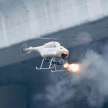
3. Flexibility: drones can easily cope with complex terrain and harsh environments, such as surveying and mapping tasks in mountainous areas, deserts, and oceans.
4. Safety: drone mapping reduces the risk of personnel entering dangerous areas and improves the safety of operations.
5. Low cost: Although the initial investment in drones and their mounting equipment is large, in the long run, drone mapping can greatly reduce labor costs and time costs.
Picture
II. Application areas
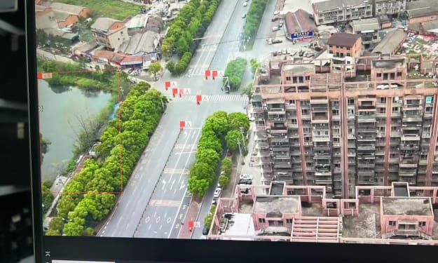
1. Urban planning: drone mapping technology can provide high-resolution images and data for urban planning, helping decision makers better understand the development status and planning schemes of the city.
2. Geographical survey: In the fields of geological survey, land resource survey, etc., drone mapping can quickly and accurately obtain large-area ground object information, providing a scientific basis for related work.
3. Environmental protection: Drones can be used for tasks such as environmental monitoring and pollution source investigation, providing important technical support for environmental protection.
4. Agricultural monitoring: In the agricultural field, drone mapping can monitor the growth of crops in real time, provide accurate fertilization, irrigation and other suggestions, and improve the efficiency and quality of agricultural production.
5. Disaster relief: After natural disasters such as earthquakes and floods, drone mapping can quickly obtain real-time geographic information of the disaster area, providing important support for rescue and reconstruction work.
Picture
III. Future development trends
1. Intelligence: With the continuous development of artificial intelligence technology, drone mapping will achieve more intelligent data collection and processing. Through machine learning and deep learning algorithms, drones will be able to independently judge and optimize mapping paths, improving the accuracy and value of data.
2. Integration: The future UAV mapping system will be more integrated, integrating multiple sensors and equipment on the UAV platform to achieve synchronous collection and processing of multi-source data.
3. Real-time: With the development of technologies such as 5G and cloud computing, the data transmission and processing of UAV mapping will be more real-time. Users can obtain mapping results in real time and make decision analysis.
4. Standardization: With the popularization of UAV mapping technology and the expansion of application fields, the formulation of relevant standards and specifications will be more perfect. This will help standardize the application and management of UAV mapping technology and improve the quality and reliability of mapping results.
In summary, UAV mapping technology has the advantages of high precision, efficiency, flexibility, safety and low cost, and plays an important role in many fields. With the continuous advancement of technology and the continuous expansion of application fields, UAV mapping technology will play a more important role in the future and contribute more to the development of human society.
About the Creator
xxj
Drone industry practitioners, hobbies of making drones and payloads, modifying drones, and customizing special drones
About Binding Prometheus
I want to start actively advocating on behalf of my own work, and the most valuable part of my canon is, without a doubt, Binding Prometheus, the play I have been working on since 2019 and only finished in 2023 as part of my MA. The play itself is an amalgamation of a million different inspirations. On one end, it evokes the Ancient Greek myth-play, deriving its own title from the earliest extant work of Western drama we have, Aeschylus’s Prometheus Bound. On the other end, it borrows significantly from the sci-fi bulwarks from over the years, namely Mary Shelley’s Frankenstein and Karel Capek’s Rossum’s Universal Robots. The play could be an episode of Black Mirror, I fear. I don’t know. I’ve only ever seen one episode of Black Mirror.
By Steven Christopher McKnight12 days ago in Futurism
Test Preparation Market Outlook: Trends, Growth & Demand
📊 Test Preparation Market Overview The global test preparation market encompasses a wide range of services and solutions designed to help learners prepare for academic, professional, and language proficiency exams. These include standardized tests like SAT, ACT, GRE, GMAT, TOEFL, and IELTS, as well as certification and licensing assessments across industries. Traditionally dominated by in-person coaching and printed study materials, the market has shifted significantly toward online delivery, mobile apps, and technology-enhanced instruction. Digital platforms now account for a growing share of user engagement due to flexibility, convenience, and scalable access to resources.
By James Smith4 days ago in Futurism
If You Love Me, You'll Do It
I met Jason when I was five years old. I could say that I loved him from the moment I saw him. He was so handsome to me and I felt in awe by his presence. When they introduced him as the new kid in school, I wanted to be his friend right away. I remember it like it was yesterday. I remember his smile and how he didn't seem shy. He appeared confident and ready to learn. I waved at him and said "hello," before anyone else could even say a word. He sat next to me, and I asked him if he wanted to be friends. He looked so happy as he said, "Yes!"
By Sidney Smith (Sid Smith)7 days ago in Fiction


Comments (1)
Wow so fantabulous