
The Piri Reis Map
The Piri Reis map, created by Ottoman-Turkish cartographer Ahmed Muhiddin Piri in 1513, has attracted significant attention due to its depiction of an ice-free Antarctic coastline. If this is true, someone had discovered and mapped Antarctica centuries before its reported discovery in 1773.

The Story
The Piri Reis Map, one of several enigmatic maps drawn in the 15th Century and earlier, presents a puzzle. It holds more accurate information about the shape of the continents than should have been known at the time, sparking intrigue and curiosity.
The Piri Reis map, created by Ottoman-Turkish cartographer Ahmed Muhiddin Piri in 1513, has attracted significant attention due to its depiction of an ice-free Antarctic coastline. If this is true, someone had discovered and mapped Antarctica centuries before its reported discovery in 1773. This revelation challenges our understanding of history and raises intriguing questions about the capabilities of ancient civilizations. Could they know the world is only known to modern science, such as the structure and function of DNA, or advanced astronomy and physics?
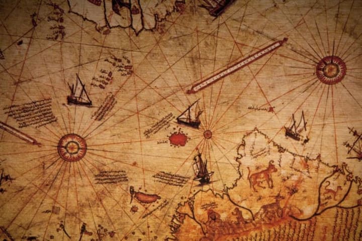
The Piri Reis Map is only one of several strange maps drawn in the 15th Century and earlier, and it appears to represent better information about the shape of the continents than should have been known at the time. In 1929, Director Halil Edhem went through the basement of a Turkish palace looking for old maps at the request of German theologian Gustav Adolf Deissmann. Edhem happened upon a very mysterious artifact. A small map was inked onto animal skin, although only a fragment remained. At first, it looked like any other aged map. However, upon closer inspection, something caught Deissmann attention. It was ultimately identified as the Piri Reis map, incorporating the only known copy of Christopher Columbus’ map.
The Piri Reis map is one of the cornerstones of the growing body of evidence for an unknown Ice Age civilization. This civilization existed during the last glacial period, leaving intriguing artifacts and mysteries behind. The Piri Reis map, with its accurate depictions and advanced cartographic techniques, is a testament to this civilization’s knowledge and capabilities.
The Piri Reis map showed Antarctica’s coastline and the proportions of the continent without its ice cap, which were only visible over 6,000 years ago. Our modern knowledge of the coastline under the ice was obtained using seismic-sounding data. This technique involves sending sound waves into the ground and measuring the time it takes to bounce back from Antarctic expeditions in the 1940s and 50s.
This data allowed us to map the coast under the Antarctic glaciers. The other way to map these coastlines would be to have surveyed them when they were ice-free. According to Hapgood, who based the claim on 1949 core samples from the Ross Sea, the last time the particular area shown in the Piri Reis map was free of ice was more than 6000 years ago. More recent studies show that this may be off by a couple of magnitude. In any case, this geography should have been unknown to the ancients. If this is correct, there are some big mysteries to explain.
In 1965, Professor Charles Hapgood from the University of New Hampshire and his students scrutinized the Piri Reis map. They were not only intrigued by its depiction of the Antarctica coastline but also by another peculiar anomaly. The map had been created using the Mercator Projection, a method of map-making that allowed for a more accurate curvature when transferring maps from paper to globe. This was a technique that European cartographers didn’t adopt until 1569, making the Piri Reis map a testament to advanced cartographic techniques that were seemingly ahead of their time.
Hapgood concluded that a civilization with high seafaring and mapping skills surveyed the entire Earth in the ancient past. They left maps that have been copied by hand through many generations. The Piri Reis map is a patchwork with gaps (most notably the Drake Passage between South America and Antarctica) that can be explained as non-overlapping areas between the source maps. Maps of the Ancient Sea Kings. Based on what we know, ancient civilizations needed the tools or capabilities to map continents on such a grand scale. So how could it have been achieved? Scholars and historians began to speculate. Paranormal researchers pointed to some extraterrestrial assistance. Others hypothesized the possible involvement of a civilization based around the Lost City of Atlantis. Does the map show an ice-free Antarctica from over 6,000 years ago? Is it proof that an alien technology once existed on Earth?
About the Creator
The Secret History Of The World
I have spent the last twenty years studying and learning about ancient history, religion, and mythology. I have a huge interest in this field and the paranormal. I do run a YouTube channel
Keep reading
More stories from The Secret History Of The World and writers in Fiction and other communities.
Volume 7: After the Sky Opens: Life in the First Days of Disclosure
Life in the First Days of Disclosure The moment humanity has waited for will not arrive with fanfare or fireworks. It will come with silence broken by a collective gasp, a shockwave of realization that spreads not from governments or generals, but from the people who look to the sky and understand that everything has changed. Disclosure will not be the end of a mystery; it will be the beginning of a reckoning. And what follows in the days, weeks, and months after will test the very soul of humanity.
By The Secret History Of The WorldExclusive • 5 months ago
The Pot Boiling Over
Once, there was a pot of about 340 million drops and droplets. Most of them would like to think they lived together peacefully for decades, but that wasn’t true. Different regions struggled, sometimes fought, with each other. And the mainstreams still often pursued and attacked the minorities. Law enforcers sometimes pushed minority drops out of the pot, never to be seen again.
By Gabriel Shames7 days ago in Fiction


Comments
There are no comments for this story
Be the first to respond and start the conversation.