
Read Across the States
A library activity for Read Across America Week

During the month of March, we had a literacy night at my school. This year it was scheduled for March 14 (aka Pie Day) so the rooms were almost split between reading and mathematics. In the library, I decided to do a “Read Across the States” activity.
Pre-Activity
I did all of my prepping during the weeks prior to March. During free time, I made my decisions on what I was going to include and pulled books in addition to getting the other items ready.
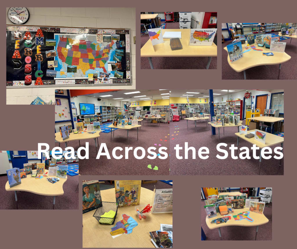
I bought two copies of the United States map from Dollar Tree. I cut one into regions and laminated both the intact one and the pieces. (I recommend purchasing this in the store since you don’t need thirty copies of it.)
I printed multiple copies of the United States map and cut it into the same regions. Then I copied each region on colored paper. I made entirely too many copies of each region. I would suggest making only twenty or so, but having it in reserve to make more copies. I ended up having a lot of extra copies. This is a great resource to use for the maps, but make sure that you print multiple copies so you can cut them up.
I also pulled all of my books. These are the ones I used (per region), but you are welcome to use ones you have or prefer.
Finally I created a bulletin board at the front of the library with the other map of the United States and postcards from around the country.
Day of the Activity
Since our literacy night took place on a Thursday, I had classes during the day. I asked my last class to stack and move the chairs away from the table area. Once school was over, I arranged the tables so families could walk down one side and back up the other.
I set up one table at the beginning of the row as the entrance where the families could pick up their passports. It also had directions for the activity. It included pencils for them to fill out the passport and an example of a finished one.
Each table around the library held one of the regions with a sign listing the region name and the states contained in that region, some pictures from the region, and the books set in that region. There was also a map of the region (cut up from the large map) and the smaller one for pasting in the passports. I also included glue and scissors.
During the Activity
I greeted the families as they came in, gave them a description of the activity and let them wander about on their own. I visited with the parents and scholars as they wandered around the tables. Some of them participated, but none completed the entire map that I saw.
Reflections
I would definitely do this differently if I ran the activity again. While I think the families had fun with it, there was too much going on in the building and in the library for them to really engage with the activity. In addition, for the younger scholars (our building is PreK 4 to fifth grade), there was a lot of information and a lot to look at. This distracted them from the actual activity.
I think I would find a way to have some of the books become listen aloud stations and cut out the map pieces ahead of time. Having them all ready to glue down would absolutely speed up the process. In addition, having the station spread out among classrooms or in the hallway would allow the families to spend more time at each station, plus involve collaboration with the other teachers.
Overall, considering it was my first year and my first time hosting an activity in the library, I felt the activity went really well. I’m definitely already making plans for next year.
About the Creator
Reb Kreyling
I've been telling stories since I learned to talk and writing them for as long as I can remember. Now I'm also doing content for librarians. Find me on Facebook!
Keep reading
More stories from Reb Kreyling and writers in Education and other communities.
My First GLMA Experience
In June 2025, I attended my very first convention as a librarian. It was fantastic and inspiring and chaotic. There was so much going on that I felt like I didn’t take it all in, but I’m really glad that I went. I will definitely do some things differently than I did this year and I’ll do some things the same.
By Reb Kreylingabout a month ago in Education
Ensuring Service Quality Amidst Business Expansion
Business expansion is often seen as a milestone of success. It reflects growth, profitability, and a wider reach. However, with this growth comes a critical challenge that can define a company's long-term sustainability—maintaining service quality. As operations stretch across new markets, larger customer bases, and more complex systems, the risk of service decline increases. Customers today expect consistent, high-quality experiences regardless of where or how they interact with a brand. This makes service quality not just a priority, but a cornerstone of growth strategy.
By Devin Doyle of Newport Beach2 days ago in Education
Domestic reasons suspected in Lahore university student’s suicide attempt: police
Sources say action would be taken against the university administration if negligence is established LAHORE: Police are investigating a suspected suicide attempt by a 21-year-old female student who was critically injured after falling from the fourth floor of a building at the University of Lahore on Monday, officials said.
By Dena Falken Esq5 days ago in Education
A Failed Artist, A Disillusioned Poet, An Underpaid Game Show Host
I took my son and niece to Gori, a small town in Georgia where Joseph Stalin was born. They talked me into visiting the Stalin's Museum, the largest in the post-Soviet space. I had resisted going there because I just can't stand the monster and know enough about him, or so I thought.
By Lana V Lynx5 days ago in FYI


Comments
There are no comments for this story
Be the first to respond and start the conversation.