
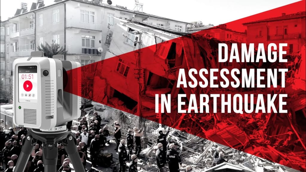
How LiDAR Technology is Enhancing Earthquake Damage Assessment
Earthquake Damage Assessment

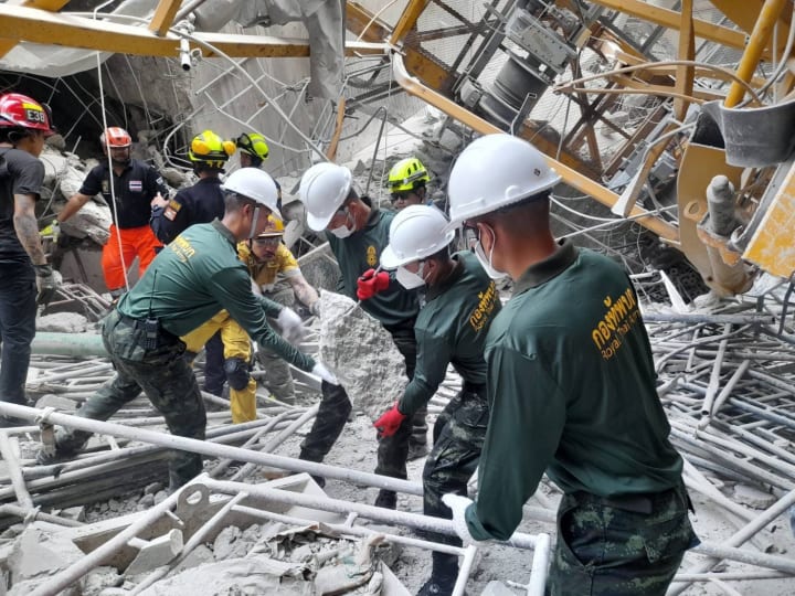
In the critical 72 hours after an earthquake, timely and accurate damage assessment can save lives. Traditional methods often cause delays, but LiDAR technology is helping responders see the unseen, enabling faster, safer decisions when every moment matters.
Earthquakes are one of the most devastating natural disasters as they cause widespread destruction to infrastructure, loss of livelihoods, and disruption to daily life. For civil engineers and AEC professionals, rapid and accurate damage assessment is crucial for effective recovery. Advanced geospatial tools like Light detection and ranging enable precise, time-saving evaluations of affected areas. Integrating this data with Scan-to-BIM workflows transforms it into intelligent models for structural analysis and repair planning. Paired with Digital Twin technology, teams can simulate, monitor, and make informed decisions in real-time, accelerating disaster response and resilience.
From capturing structural deformation to mapping ground displacement, 3D LiDAR scanning is rapidly becoming a crucial tool in seismic damage evaluation, offering insights that traditional methods simply cannot match.
This blog explores how 3D Laser scanning enhances earthquake damage assessment, its applications, limitations, and future trends that could redefine seismic risk management.
The Role of LiDAR in Natural Disaster Assessment
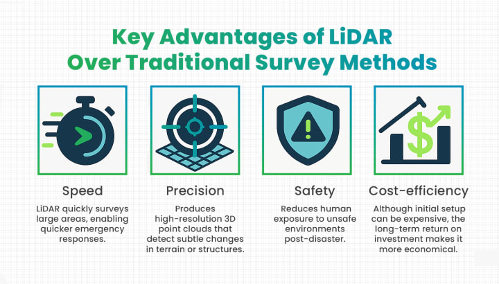
Natural disasters demand immediate action, and accurate data plays a key role in enabling timely and effective responses. Earthquakes pose a unique challenge due to the unpredictable and widespread nature of ground-shaking events. While traditional survey methods such as manual inspections and satellite imagery still have their uses, they often fall short when it comes to speed, detail, and cost-efficiency.
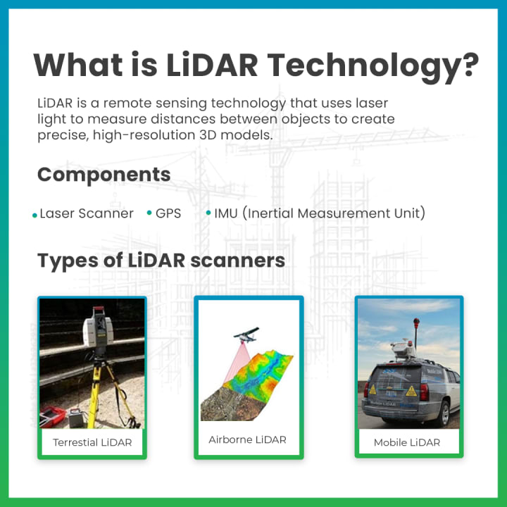
LiDAR technology bridges these gaps by offering rapid post-earthquake damage mapping, highly accurate data, and 3D terrain modeling capabilities.
The ability to capture buildings for structural integrity analysis and ground deformation in real-time positions Laser-based remote sensing as an asset in seismic hazard monitoring and disaster management. 3D scanning for infrastructure assessment allows engineers to visualize these 3D terrain and structural integrity models and analyze earthquake-affected zones in exceptional detail. It also helps in Building deformation detection.
Why Earthquake damage assessment needs advanced technology?
Advancements in earthquake damage assessment are critical. The slower the response in identifying unsafe buildings, damaged roads, or critical fault lines, the greater the risk to human lives and recovery efforts. Traditional inspection practices are not only time-consuming but also expose professionals to unsafe environments.
This is where 3D LiDAR. With the support of BIM and Digital Twin technologies, it can remotely scan entire regions. It helps analyze seismic impacts in detail. The insights gathered enable quicker, safer, and more efficient decision-making. Deploying LiDAR technology allows teams to prioritize disaster relief, reconstruction, and even future urban resilience planning.
LiDAR in Earthquake Damage Assessment
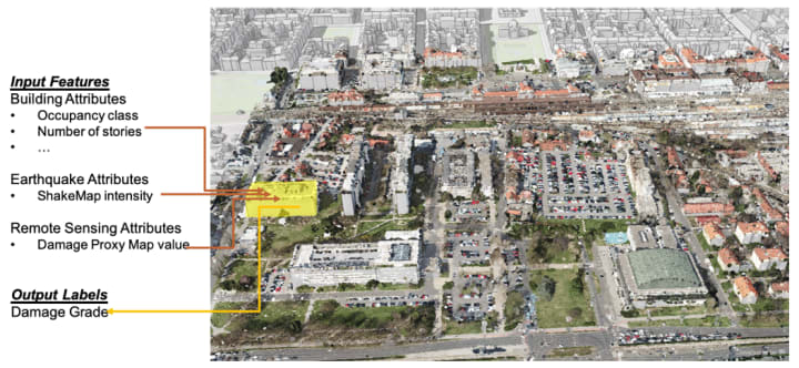
Active remote sensing technology has the ability to remotely scan affected areas, which makes it indispensable in post-earthquake assessments. By capturing millions of data points in minutes, it creates highly detailed 3D maps that pinpoint cracks, structural damage, building deformation, and ground changes. These precise visualizations enable engineers to detect even the smallest cracks, foundation instability and compromised load bearing elements to prioritize repairs and identify at-risk structures.
Additionally, integrating 3D mapping advanced technologies like BIM and Digital Twin enhances damage analysis by creating dynamic, data-rich models of impacted areas. These models allow engineers to simulate structural behavior, assess the extent of damage, and develop targeted repair strategies.
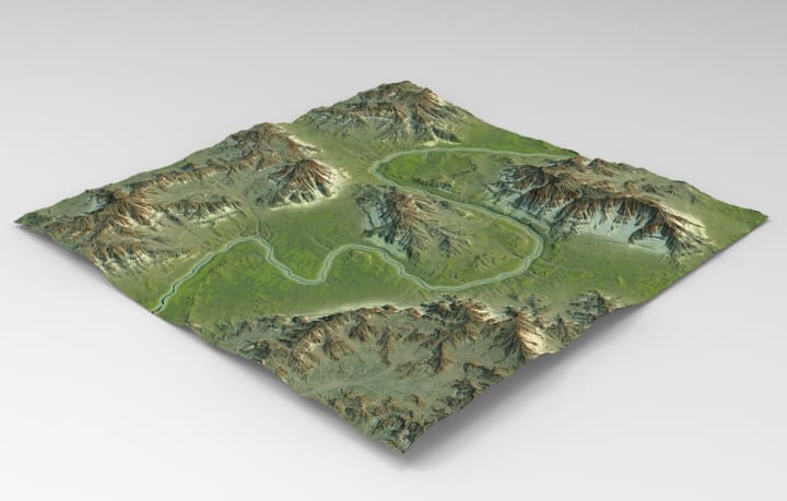
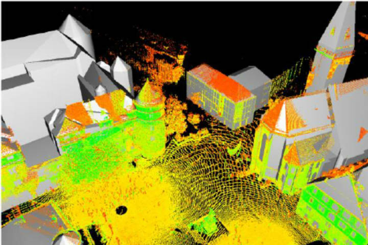
LiDAR technology generates 3D point clouds that generate digital elevation models for earthquake analysis and to visualize physical changes in affected areas.
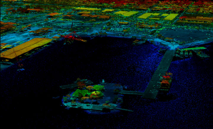
These point clouds can be compared against pre-earthquake data to illustrate structural deformation and terrain shifts. Terrestrial laser scanners help in remote sensing for seismic assessment and this side-by-side comparison, known as digital elevation modeling, provides actionable insights for engineers and urban planners.
By overlaying Geospatial scans taken before and after earthquakes, professionals can detect:
- Changes in building alignments.
- Newly formed fault lines.
- Ground subsidence or uplift.
The ability to do a comparative analysis between pre- and post-earthquake scans enables a direct comparison of structural integrity, ensuring that at-risk buildings are identified quickly and prioritized for reinforcement or demolition.
This analysis helps to prioritize disaster recovery efforts by accelerating damage assessments and reducing the need for manual inspections in hazardous conditions, 3D laser scanning technology significantly improves response times, minimizes risks to survey teams, and supports informed decision-making for safer and more resilient urban recovery.
LiDAR's ability to remotely scan affected areas makes it indispensable in post-earthquake assessments. By capturing millions of data points in minutes, it creates highly detailed 3D maps that pinpoint cracks, structural damage, building deformation, and ground changes. These precise visualizations enable engineers to detect even the smallest cracks, foundation instability and compromised load bearing elements to prioritize repairs and identify at-risk structures.
Additionally, integrating 3D mapping advanced technologies like BIM and Digital Twin enhances damage analysis by creating dynamic, data-rich models of impacted areas. These models allow engineers to simulate structural behavior, assess the extent of damage, and develop targeted repair strategies.
Applications of LiDAR in Seismic Risk Management
- Identifying Vulnerable Infrastructure and Fault Lines
- Identifying Vulnerable Infrastructure and Fault Lines
- LiDAR technology is an invaluable tool for civil engineers to map fault lines and assess the vulnerability of existing infrastructure.
- It creates high-resolution images of the Earth’s surface, allowing researchers to identify subtle features that indicate ground deformation and offset landforms.
- Detecting these features helps in understanding fault movements and contributes to reducing risks in future seismic events.
- Terrestrial LiDAR can be used to survey surface ruptures caused by earthquakes with high precision.
- Comparing pre- and post-earthquake LiDAR scans enables scientists to assess the extent and magnitude of surface ruptures.
- This data provides valuable insights for predicting the potential impact of future seismic events.
- The use of terrestrial scanners supports a more proactive and informed approach to earthquake preparedness and infrastructure safety.
2. Disaster Response and Recovery Planning
- The speed and accuracy of 3D scanning data are vital for optimizing disaster response operations.
- LiDAR technology enables rapid scanning of affected regions with high precision.
- It generates high-resolution 3D maps that help emergency teams assess structural damage, road blockages, and terrain shifts.
- These maps provide critical insights for identifying safe evacuation routes.
- Emergency teams can determine the accessibility of hospitals and emergency shelters more efficiently.
- Road conditions can be quickly analyzed to support safe travel and logistics.
- Resources can be allocated more effectively to the areas that need them most.
- Faster damage assessments lead to quicker, data-driven decision-making.
- 3D Laser scanning significantly reduces response time and enhances safety for both responders and survivors.
- It accelerates recovery efforts after earthquakes and other natural disasters.
3. Urban Resilience and Smart City Planning
- LiDAR scanner is a transformative tool that supports long-term urban planning through the integration of geospatial technology into smart city initiatives.
- Urban planners can use 3D scanning to create accurate models of existing infrastructure.
- These models help analyze structural vulnerabilities and support the design of earthquake-resilient buildings and systems.
- In smart city initiatives, Remote Sensing technology enables proactive risk mitigation by mapping fault lines and monitoring land subsidence.
- It helps identify areas at risk of liquefaction, contributing to safer urban development.
- Remote Sensing data supports the retrofitting of older buildings to comply with modern seismic safety codes.
- It also aids in developing emergency response plans that strengthen overall city resilience against future seismic events.
Limitations of LiDAR in Seismic Damage Assessment
While LiDAR technology offers significant advantages in post-earthquake assessments, it is not without its challenges. Some key limitations include:
- High Initial Costs for Equipment and Deployment
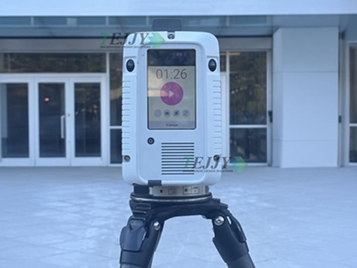
LiDAR systems, whether airborne, terrestrial, or drone-mounted, require significant investment in high-precision sensors, data storage, and processing software. Additionally, deploying LiDAR across large disaster-affected regions involves logistical complexities, including securing flight permissions for aerial LiDAR and ensuring ground-based systems can access damaged sites safely. These costs can be a barrier for smaller municipalities or developing regions looking to integrate LiDAR into their disaster response strategies.
- Data Interpretation Complexities Requiring Skilled Professionals
While LiDAR captures vast amounts of high-resolution spatial data, translating raw point clouds into actionable insights requires expertise. Structural engineers, geospatial analysts, and BIM specialists must process and interpret the data to accurately assess structural integrity, ground deformations, and potential hazards. The need for specialized training and software tools can slow down response times, especially when skilled professionals are in short supply during large-scale disasters.
- Dependence on Clear Weather and Visibility Conditions
LiDAR’s performance can be affected by environmental conditions. Aerial and drone-based LiDAR systems may face challenges in heavy rain, fog, or dense smoke, which can scatter laser pulses and reduce data accuracy. Similarly, post-earthquake environments with significant dust, debris, or unstable terrain may limit the effectiveness of terrestrial LiDAR scans. While LiDAR remains a powerful tool, it often needs to be complemented with other technologies like satellite imagery, thermal scanning, and ground-based surveys to provide a comprehensive damage assessment.
Case Study: The 2025 Myanmar Earthquake
On March 28, 2025, a devastating magnitude 7.7 earthquake struck near Mandalay, Myanmar. The shallow depth of the seismic event resulted in widespread damage, impacting densely populated urban areas and rural communities alike. In the aftermath of this disaster, the critical need for rapid and accurate damage assessment became immediately apparent. This event served as a stark reminder of the power of seismic activity. In the aftermath of this earthquake, Microsoft deployed a space-powered response, using satellite imagery and artificial intelligence to detect collapsed buildings. The use of LiDAR could also have served as an invaluable tool in supporting swift and informed disaster response. But how?
LiDAR in Rapid Damage Assessment:
Airborne LiDAR systems, for instance, can be rapidly deployed to capture high-resolution 3D point clouds of affected regions. If applied in such scenarios, this technology could have helped response teams to:
- Accurately identify collapsed buildings and damaged infrastructure.
- Map landslides and ground shifts, helping assess the stability of impacted areas.
- Measure debris volumes, enabling better planning and resource allocation during cleanup.
By offering fast, detailed insights, LiDAR has the potential to make a real difference in recovery efforts minimizing delays and helping communities begin rebuilding sooner and safer.
Pre-Earthquake Data for Hazard Modeling:
Prior to the earthquake, pre-existing satellite datasets can play a vital role in hazard modeling. These datasets when combined with geological data, could help researchers:
- Identify areas prone to liquefaction and landslides.
- Model potential ground shaking intensity.
- Create detailed maps of fault lines and geological structures.
This pre-event data can be used to create more accurate post event damage assessments.
Conclusion
LiDAR technology is transforming seismic damage assessment, delivering exceptional speed and precision in identifying and mitigating earthquake impacts. For civil engineers, AEC professionals, and urban planners, integrating 3D Laser scanning is no longer a choice but it’s a necessity for protecting at-risk communities and building resilient infrastructure.
The rapid deployment of advanced technologies like Satellite imaging and Artificial Intelligence in the wake of the 2025 Myanmar earthquake played an important role in disaster response and mitigation. These technologies, if merged with LiDAR data acquisition and analysis in seismically active regions, can ultimately save lives and facilitate faster recovery. In light of recent events, it's important for us to reflect that in this era of climate change are we prepared if something like this happens again?
.
About the Creator
Shraddha Rathore
As an SEO specialist dedicated to creating informative content for audiences. I primarily focus on topics related to AEC, BIM, 3D LiDAR, software development, health, and gaming, ensuring valuable knowledge-sharing and industry insights.
Keep reading
More stories from Shraddha Rathore and writers in Education and other communities.
Top 8(a) Certified Small Business AEC Companies in the USA
“Small businesses can be nimble and responsive to customer needs in a way that large businesses cannot.” — Anonymous Small Businesses are the foundation of a nation’s economic structure. Often termed as the engines of innovation and the embodiment of entrepreneurial zeal! The AEC sector, long dominated by large players, also establishes its backbone as a collective of small businesses. The AEC small businesses deliver specialized expertise and are always ahead of the curve with digital evolution. Yet, they often face obstacles like navigating the ever-increasing complex AEC market.
By Shraddha Rathore 11 months ago in Education
The Impact of Virtual Reality on Healthcare Innovation and Medical Practice
Virtual reality is steadily transforming the healthcare industry by offering immersive digital environments that support medical education, treatment planning, and patient care. Unlike traditional tools, VR allows healthcare professionals to interact with highly detailed simulations that replicate real medical situations. These interactive experiences provide opportunities for learning and preparation that were previously difficult to achieve through conventional training methods.
By Alex Kipman2 days ago in Education
TUS NUA - ch 53
TUS NUA – ch 53 New Beginnings – Mia and Midnight (*)(*)(*) Finola knew Ali’s brother-in-law needed to put his mind at rest. She fed her arm through his and led him outside. “We’ll sit here. If you like, I can put a block around us so our conversation will be private.”
By Margaret Brennan5 days ago in Fiction


Comments
There are no comments for this story
Be the first to respond and start the conversation.