
3 Ways Python-Driven Geospatial Machine Learning Could Save The Amazon
Why python?

I want to write an article about a serious problem that the entire globe is facing and that many people should be concerned about. One of the most pressing issues that should concern us all as climate change becomes a reality in the twenty-first century is the swift decline in biodiversity. This disturbs the delicate balance of life on Earth, damages ecosystems, and impedes food security.
However, there is a rare chance to better address climate change and biodiversity loss with the development of technologies like machine learning and spatial analysis. For conservation, resource management, and environmental restoration, these technologies offer real-time monitoring, predictive insights, and optimal solutions.
This article will examine three possible applications of python driven geospatial machine learning backed by python to Amazon protection around 2025. We will discuss how this cutting-edge technology may be used to monitor deforestation as it happens, anticipate environmental issues before they worsen, and bolster reforestation efforts in order to restore and protect one of the planet’s most significant ecosystems. By using machine learning, satellite photography, and spatial analysis, we can come up with creative approaches to preserve the Amazon and its priceless biodiversity.
Why Is This Significant?
The Amazon rainforest is commonly called the “lungs of the Earth” since it generates 20% of the planet’s oxygen and serves as a vast carbon sink, playing a crucial role in lessening climate change. In addition to its vital function in climate regulation, the Amazon boasts an extraordinary level of biodiversity, housing millions of species of plants, animals, and insects, many of which are unique to this region.
Protecting the Amazon is not merely a local concern; it is a shared global duty. The destruction of this essential ecosystem would lead to severe repercussions, such as:
Rising Global Temperatures: Deforestation reduces the Amazon’s capacity to absorb carbon, resulting in increased greenhouse gas emissions in the atmosphere.
Threat to Global Biodiversity: The Amazon is home to nearly 10% of the known species on Earth. Its disappearance would be disastrous for global biodiversity and ecosystems.
Effects on Indigenous Communities: Millions of Indigenous individuals rely on the Amazon for their sustenance, cultural identity, and survival.
By utilizing advanced technologies like python driven geospatial machine learning, we can create more efficient strategies to address these dangers and safeguard the Amazon for generations to come.
The Current State of The Amazon
About 26% of the forest was deemed deforested or severely degraded by 2022. The Council on Foreign Relations reports that the loss is 300,000 square miles.
The rhythm of life runs in cycles. There are times in the darkness and times in the light. The energy of life is like the rainforest in Borneo.” — Olympia Dukakis, American actress
The rate of deforestation in the Amazon reached a 10-year high between August 2017 and July 2018, according to satellite data from 2018. The projected loss of land was 7,900 km2 (3,100 sq mi). During this time, the states with the highest rates of deforestation were Mato Grosso and Pará. Critics referred to the expansion of agribusiness as another reason encroaching on the rainforest, while the Brazilian environment minister mentioned illicit logging as one of the causes.
Why Python?
Python has become the most popular programming language for geographic machine learning because to its vast library ecosystem, perfect for beginners, robustness ease of use, and exceptional interoperability. It offers specialized python driven geospatial libraries like GDAL, Rasterio, Plotlib and Geopandas for handling and analyzing geographical data in order to find deep and meaningful insights. In addition to powerful machine learning frameworks like TensorFlow, PyTorch, and Scikit-learn for building and implementing models that will bring further understanding to the situation at the Amazon. Python’s simple syntax, which is understandable by both beginners and specialists, enables collaboration between data scientists and subject matter experts.
How Python Powered Machine Learning and Spatial Analysis Can Help
How CNNs Work for Object Detection:
Convolutional Neural Networks (CNNs) are a type of deep learning algorithm that excels at processing visual data. Within the framework of geospatial surveillance and threat identification in the Amazon, CNNs can identify particular objects or activities in satellite imagery, such as unlawful logging, land clearing, or mining activities.
Image preprocessing: A CNN model is fed satellite photos of the Amazon. These photos may go through preprocessing methods to improve specific attributes, such contrast or resolution, to make the relevant objects easier to detect before putting the data into the network.
Convolutional Layers: A sequence of convolutional layers is used by CNNs to automatically learn and extract pertinent information from images, including forms, edges, and textures. CNNs can be trained to identify patterns in satellite photos that show signs of human activity, including roads, areas used for clearing, or certain pieces of machinery.
Object Localization and Classification: CNNs are made to be able to locate things in addition to classifying them. By creating bounding boxes around the objects of interest (such as logging trucks, bulldozers, or cleared land), the model may therefore precisely locate instances of deforestation or illicit activity inside the satellite image.
Post-Processing: Following detection, the system can produce warnings for the appropriate authorities and usually identifies the areas of interest that have been detected. This enables continuous monitoring of illicit land use or deforestation and near-real-time response.
Logging Activity Detection: Certain indicators of logging, including roads incorporated into woods or tree removal, can be recognized by trained CNNs. The algorithm can automatically identify new occurrences of logging from satellite pictures after it has been trained on annotated images of logging activity.
Identify and Clearing: CNNs are able to locate land being cut down for urbanization or agriculture. CNNs are able to identify unlawful land conversion activities by learning the features of cleared land, such as the absence of vegetation and soil disturbances.
Mining and Construction Detection: In once forested areas, CNNs can also identify construction sites and mining activities. CNNs can learn to identify the unique indicators that these operations usually leave in satellite imagery, like vehicle tracks or excavation sites.
A nation that destroys its soils destroys itself. Forests are the lungs of our land, purifying the air and giving fresh strength to our people.” — Franklin D. Roosevelt, 32nd President of the United States.
Example in Action
To identify illicit logging and deforestation in the Amazon, a CNN-based system was created in Brazil. Thousands of satellite photos of both forested and unforested regions were used to train the algorithm. When the system was put into place, it could detect illicit logging activity almost instantly, which allowed authorities to respond quickly and possibly save hundreds of hectares of forest.
2. Change Detection Algorithms for Monitoring Deforestation
Change detection algorithm for monitoring deforestation, In order to detect and track deforestation in the Amazon rainforest, change detection algorithms are essential. These algorithms identify regions where the landscape has altered, such as forest loss from logging, mining, or agricultural growth, by analyzing satellite pictures captured at various times.
Image Acquisition: To provide a chronological record of the condition of the forest, high-resolution satellite photographs are taken over the Amazon on a regular basis. Because of their dependability and steady coverage, sources like the satellites of Landsat, Sentinel, and Planet Labs are frequently used.
Image Preprocessing: To guarantee uniformity, the photos are preprocessed to account for changes brought on by lighting, climatic conditions, and sensor variations. To clean up the data, methods like cloud masking and image normalization are used.
Pixel-by-Pixel Comparison: Algorithms for change detection examine corresponding pixels in pictures captured at various points in time. Pixel value changes show variations in land cover, such as infrastructure or bare terrain replacing forest.
Popular Change Detection Techniques:
By examining how plants reflect light, the NDVI calculates the health of the vegetation. An easy-to-use yet powerful instrument for tracking deforestation is the NDVI, which indicates vegetation loss when values fall between two time periods.
Image Differencing: To draw attention to changes, this method subtracts pixel values from two images. Significant discrepancies are noted for additional research in those areas.
Principal Component Analysis (PCA): PCA highlights areas of change while simplifying visual data. In large-scale, multitemporal analysis, it is especially helpful.
Applications in Threat Detection:
Early Warning Systems: When deforestation takes place, change detection systems send out signals almost instantly, allowing law enforcement to swiftly stop illicit activity. Newly cleared terrain or growing logging routes, for instance, can be marked for quick attention.
Evaluation of Fire Damage: In a short period of time, wildfires can completely destroy extensive tracts of forest. By comparing pre- and post-fire footage, change detection algorithms can determine the level of damage.
Continuous Monitoring: By using these techniques, it is possible to track the Amazon over time and get a complete picture of how the jungle is developing.
Scalability: The ability of change detection algorithms to handle enormous volumes of satellite data makes routine monitoring of the whole Amazon rainforest possible.
Example in Action:
Over a five-year period, a study that used Landsat data and NDVI-based change detection found hotspots for illegal deforestation in the Amazon. Researchers were able to identify small-scale logging operations that would have gone undetected by conventional monitoring techniques by automating the procedure. Large tracts of rainforest were preserved because to the targeted enforcement efforts made possible by this early detection.
3. Reinforcement Learning for Conservation Strategy Optimization
Reinforcement Learning (RL) is an advanced machine learning technique that can play a crucial role in optimizing conservation efforts in the Amazon rainforest. By modeling complex systems and dynamically adjusting strategies, RL provides decision-making tools for protecting the Amazon in the face of environmental and human-induced challenges.
Agent and Environment: RL works with an “environment” (such as the Amazon rainforest and its hazards) that interacts with an “agent” (such as a conservation policy or surveillance plan). The agent acts, monitors results, and gets feedback in the form of incentives or sanctions.
Goal Definition: To achieve successful conservation outcomes, such as decreased deforestation, enhanced biodiversity, or effective resource allocation for surveillance, the RL model is trained to maximize cumulative rewards.
Applications in Threat Detection and Conservation:
Forest Restoration: RL models can identify the best locations for reforestation projects by considering factors including soil quality, distance from water sources, and the likelihood of human involvement.
Anti-Poaching Measures: In addition to combating deforestation, RL can predict the movements of unauthorized hunters and optimize patrol routes for anti-poaching teams based on historical data and environmental characteristics.
Reinforcement Learning Algorithms:
Q-Learning: A traditional reinforcement learning algorithm that determines the optimal course of action for attaining long-term rewards by learning the value of actions in specified states.
Use Case: Designating high-priority areas for surveillance drones.
Q-learning and deep neural networks are used in Deep Q-Networks (DQN) to process high-dimensional data, including ecological simulations or satellite photos.
Use Case: Teaching agents to recognize and react to intricate patterns of deforestation.
Policy Gradient Methods: These algorithms maximize predicted benefits for conservation efforts by learning directly from the policy.
Why Reinforcement Learning Is Effective:
Proactive Approach: RL makes it possible for conservation tactics to foresee and stop hazards before they cause harm, as opposed to only responding to them after it has already happened.
Adaptability: RL systems are well-suited for dynamic and complicated environments like the Amazon rainforest because they learn and get better over time.
Effective Use of Resources: RL makes sure that scarce conservation resources are used where they can make the biggest difference by optimizing choices.
Final Thoughts
The Amazon rainforest, sometimes referred to as the “lungs of the Earth,” is not only a priceless natural resource but also a vital component of the worldwide effort to combat climate change. Adopting creative strategies to protect this crucial ecosystem is becoming more urgent as the challenges to its survival increase.
In this battle, python driven geospatial machine learning provides a glimmer of hope by fusing state-of-the-art technology with useful insights. These technologies offer previously unheard-of capabilities to safeguard the Amazon, from using Convolutional Neural Networks (CNNs) to detect illicit deforestation in real time, to using change detection algorithms for ongoing monitoring, and to using reinforcement learning for the best conservation tactics.
About the Creator
Stephen Chege
I write about cool stuff
Keep reading
More stories from Stephen Chege and writers in Earth and other communities.
How to Build a python Minimum Viable Product (MVP) for Your GIS Startup
The conceptual stages of a startup is the most pivotal part of the success and as it sets the foundation for the product's direction, ensures alignment with user needs, and establishes a clear roadmap for development, ultimately determining whether the startup can effectively solve a real-world problem and gain traction in the market
By Stephen Chege12 months ago in Earth
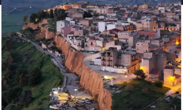
Huge Landslide Leaves Sicilian Homes Teetering on Cliff Edge
A massive landslide in Sicily has left dozens of homes perched dangerously on the edge of a collapsing cliff, forcing evacuations and raising urgent concerns about safety, climate resilience, and long-term urban planning. The dramatic incident unfolded after days of heavy rainfall weakened the soil beneath a coastal residential area, causing large sections of land to slide away into the sea.
By Sajida Sikandar5 days ago in Earth
‘Final Nail in Coffin’: Scottish Sector Under SNP Tax Threat
A growing political and economic debate is unfolding in Scotland as critics warn that proposed or expanding tax pressures under the Scottish National Party (SNP) government could act as the “final nail in the coffin” for a struggling sector of the economy. Business groups, industry leaders, and political commentators are increasingly raising concerns about competitiveness, investment, and long-term sustainability.
By Aarif Lashari2 days ago in Earth
Not Just For Clean Up: A History Of The MCU's Department of Damage Control
Initially an organisation that seemed to exist to help the heroes of the Marvel Cinematic Universe, from Phase Four onwards, the Department of Damage Control has shifted into a more antagonistic role. Most recently seen in the Wonder Man series, the current incarnation of Damage Control seems to target superpowered individuals, regardless of whether that person poses an active or intentional threat.
By Kristy Andersona day ago in Geeks


Comments
There are no comments for this story
Be the first to respond and start the conversation.