
Reaching your destination with the help of satellites
Have you ever thought about how GPS tells you where your destination is?


You are driving to a location filled with confidence, and you decide to wing it. You are going straight and straight and straight, and then there is no more straight. Now, the only way out for you is to whip out your phone and turn on your GPS. But have you ever thought about how GPS tells you where your destination is?
Humans have looked to the skies to find their way since ancient times. Ancient sailors used the constellations in the night sky to figure out where they were and where they were going. But today, all we need is a simple GPS handheld device to know where you are and the best possible route to reach there in a minimum amount of time.

We still need to look far into the skies but we have replaced the stars with artificial objects to get the accuracy we need. Instead, of stars we use satellites.
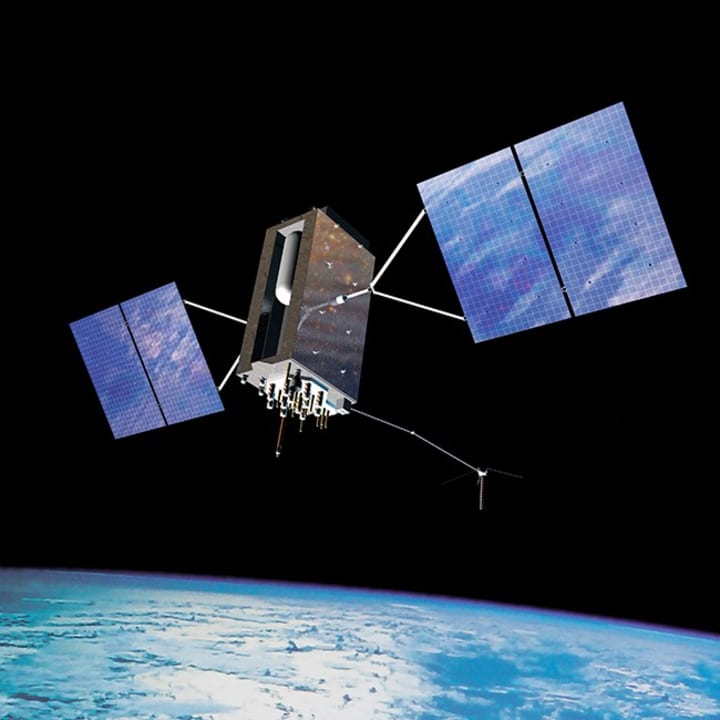
GPS, or the Global Positioning System, is a global navigation satellite system that provides location, velocity, and time synchronization. The satellite system consists of a constellation of 24 satellites in six Earth-centered orbital planes, each with four satellites, orbiting at 20,000 km above Earth and traveling at a speed of 14,000 km/h.
There Are Currently 32 GPS Satellites in Orbit. To achieve global coverage for GPS, 24 satellites are required. But, they only last about 10 years, and often need servicing during their lifetime, which is why there are currently 32 GPS satellites in orbit. The extra satellites fill in the gaps when the core 24 satellites need to be serviced or decommissioned, so that coverage is maintained.
What is GPS?
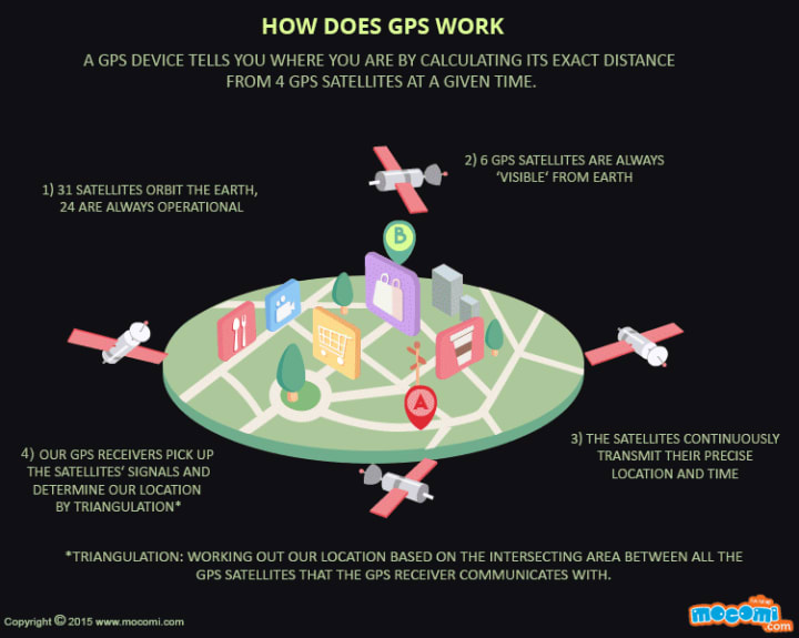
GPS is made up of 3 components that communicate with each other — satellites (the ones which are up above the world so high), ground stations, and the receiver (device on our hands).
Satellites act like the stars in constellations — we know where they are supposed to be at any given time.
The ground stations use radar to make sure they are actually where we think they are. These are located on every continent.
A receiver, as you might find in your phone, is constantly listening for a signal from these satellites. The receiver figures get the signal and tell you how far you are.
This is the fun part…How Does It Calculate your distance?
GPS works through a method called Trilateration. It is a big fancy word but let us break this down.
Suppose, Ram is in Delhi but shhh, he doesn’t know that. So naturally, he asks the people around him. Person A who is from Rajasthan tells him that he is 270 km away from Jaipur. But this will not reveal his whereabouts as there is a circle of location 270 km around Jaipur as its center. So, he asks another person and he tells that he is 276 km from Chandigarh. So till now, he has narrowed down his location to 2 places. Visualize it as the the intersection of 2 circles i.e. 2 points. To know the exact location, he requires distance from another point, let’s just say he is 715 km away from Allahabad (Prayagraj, if you have become used to that name). Now the intersection of three circles is a unique point, which is the location of Ram.
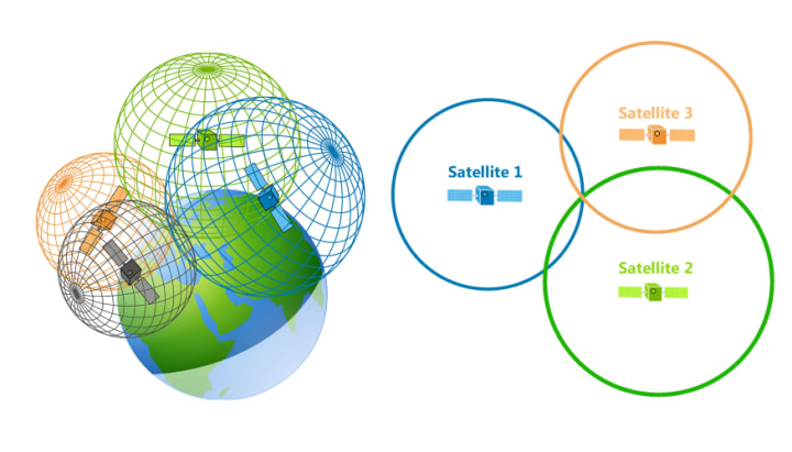
Now let’s take it up a notch. Since everything is 3D in the real world, Circle gets converted into a sphere. The intersection of three spheres produces two points of intersection, so the point nearest Earth is chosen. As a device moves, the radius (distance to the satellite) changes. When the radius changes, new spheres are produced, giving us a new position. We can use that data, combined with the time from the satellite, to determine velocity, calculate the distance to our destination and the ETA.
However, by taking a measurement from a fourth satellite, the receiver avoids the need for an atomic clock and provides a greater accuracy in finding your location. Thus, the receiver uses four satellites to compute latitude, longitude, altitude, and time.
Fun Fact
In the beginning, GPS was called Navstar. The first fully developed GPS satellite was launched in 1989 by US military. But, here’s the fun part, American taxpayers fund the worldwide GPS service, which is free to other countries. To keep the GPS service running, US taxpayers spend a staggering $2 million each day.
Application
Up until now, we’ve scrutinized how you can use GPS receivers to tell you where you are, to navigate between points, and to make digital maps of various features. But GPS isn’t just used by civilians; it’s also utilized by pilots, captains, farmers, scientists, and the military (just to name a few!). While typical civilian handheld GPS receivers are usually accurate to about 5 meters, there are also very expensive, highly advanced GPS receivers that are capable of providing positions accurate to within a centimeter!
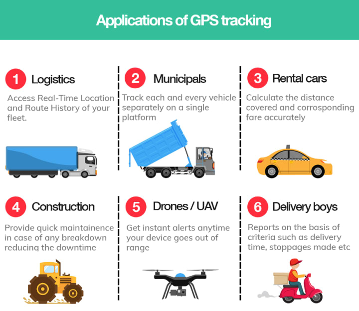
These receivers have revolutionized lots of industries, where highly accurate positioning is used for so many different tasks. GPS has so widespread that GPS shoes are available in the market now, mainly aimed at locating people with Alzheimer’s disease, in case they get lost.
The ancient sailors and travelers would be astounded if we give them GPS for their voyage.
About the Creator
Bleeding Edge
A one-stop destination for all the tech around the world. Bleeding Edge is an analytics hub, sharing top softwares, companies, rankings and reviews.
Keep reading
More stories from writers in 01 and other communities.
2026 Platform Choice Mobile App Development Native vs Hybrid
In 2026, mobile app development native vs hybrid is no longer a framework debate. It reflects a tectonic shift inside the Google ecosystem where AI Retrieval, Zero Click discovery, and entity-level evaluation now shape risk exposure, authority loss, and strategic realignment for every mobile product.
By Samantha Blake5 days ago in 01
How James Kodrowski Builds Scalable Businesses and Long-Term Investments
James Kodrowski is widely recognized as an Entrepreneur, Business Leader & Investor known for building scalable businesses while maintaining a disciplined, long-term investment mindset. His approach combines financial intelligence, operational excellence, and leadership-driven strategy, making his work highly relevant across Finance & Financial Services, Business Strategy & Operations, and Entrepreneurship & Leadership.
By James Kodrowski5 days ago in 01


Comments
There are no comments for this story
Be the first to respond and start the conversation.